
LiDAR Mapping
Turn Accurate Site Data Into Actionable 3D Intelligence
Surveying an area prior to development helps you understand what is possible for a project. Enlist our experts to collect the electronic data required to complete your land management projects and facility planning with precision.
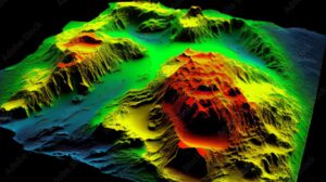

About Our LiDAR Mapping Services
We offer LiDAR services exclusively for above-ground structures. LiDAR technology measures elevation information by targeting light onto surfaces. An optical laser fires a signal toward your facility or above-ground structure — once a signal is sent back, the equipment learns the intricacies of the structure or facility.
Altamira relies on LiDAR technology to generate 3D renderings. Our professionals use state-of-the-art LiDAR equipment to provide you with data on an efficient timeline. We’ll provide you with a detailed report of our findings so that you can continue with your project and complete tasks by the deadline.
Industries We Serve for LiDAR Mapping Services
At Altamira, we stand out from competing LiDAR survey companies by offering services to several industries. Our representatives will elaborate on our LiDAR service capabilities for:
- Oil and gas: Use our LiDAR services to complete small- and large-scale natural gas projects
- Petroleum refineries: Grow your petroleum-focused company knowing where you can place tanks and equipment
- Power generation: Have our experts survey land to determine how many electrical grids and lines you can construct
- Real estate development: Learn a specific location’s geography to create blueprints and anticipate future electrical needs
- Industrial manufacturing: Decide on the scope of your industrial plant before construction
- Chemical manufacturing: Plan for expansion by knowing the size of the chemical manufacturing facility you can create
For more details, download our GIS brochure.
Benefits of Our LiDAR Services
Choosing Altamira for LiDAR mapping puts you in control. Our LiDAR technology is fast-moving to save you time and money. The point cloud mapping technology we use to finish your project lets us work efficiently, as we can survey hundreds of acres per day.
Additional benefits of using LiDAR mapping companies for your work include:
- Creating 3D renderings when areas are covered in foliage and plants.
- Seeing detailed images that show elevation information.
- Recognizing shifts in land and water sources.
- Discovering a site’s lowest and highest points above ground.

A Straightforward LiDAR Mapping Process
Leave it to the professionals at Altamira to select the right LiDAR mapping equipment for your needs. We’ll learn the scope of the job and conduct our LiDAR assessment at a time that makes sense for you.
Collaborate with our team from the initial LiDAR planning stages to completion. We’ll share a comprehensive report of our findings with you so that you can generate accurate models, blueprints and related resources.

Frequently Asked Questions About LiDAR Mapping
Learn more about LiDAR mapping services with Altamira.
LiDAR is preferred when you need to cover large areas efficiently, access terrain that is difficult or unsafe for ground crews, capture dense three-dimensional data for analysis or minimize field time while maximizing data coverage. For linear infrastructure like pipelines, LiDAR significantly reduces survey costs while delivering richer spatial datasets than traditional methods.
Altamira delivers LiDAR point cloud datasets, digital elevation models (DEMs), digital terrain models (DTMs), contour maps orthomosaic imagery, slope and aspect analysis and GIS-ready spatial layers. Deliverables are formatted to meet project specifications and integrate directly with GIS platforms and engineering design software.
Airborne LiDAR typically achieves vertical accuracy of 5 to 15 centimeters and horizontal accuracy of 15 to 30 centimeters, depending on flight parameters and ground control. Mobile ground-based LiDAR can achieve millimeter-level accuracy. For most pipeline corridor and environmental applications, LiDAR accuracy meets or exceeds project requirements at a fraction of the cost of conventional survey.
LiDAR mapping is used in the energy industry for pipeline corridor surveys, right-of-way mapping, slope stability analysis, floodplain delineation, vegetation encroachment monitoring, facility as-built surveys and corridor comparison for new route selection. It provides high-accuracy geospatial data faster and safer than traditional ground survey methods.
LiDAR (Light Detection and Ranging) is a remote sensing technology that uses laser pulses to measure distances and generate highly accurate three-dimensional point clouds of terrain, structures and vegetation. The data is processed into digital elevation models, surface models and engineering deliverables used for design, inspection and environmental assessment.
Altamira’s point cloud mapping technology and sensors are meticulous. We offer detailed 3D renderings that show you everything from individual trees and people to large hills and sinkholes present in your location.
Why Choose Altamira for LiDAR Services?
Altamira stands out from competing LiDAR mapping companies:
- We provide strategy, consulting, technical expertise, and digital technology solutions.
- Our experts streamline and simplify your projects.
- Our brand is well-known in the energy industry.
- Our pricing for LiDAR services is custom.
Reach out to Altamira to Plan Your LiDAR Mapping Project
We look forward to helping you. Contact Altamira online for more information about our services.
